
Our services
Our drone mapping services provide detailed, easily accessible maps and data, whether you’re tracking the health of your crops or monitoring critical stages of construction projects. With the comprehensive insights we deliver, you can visualize and understand your land like never before, enabling more informed decisions with unmatched clarity.
We offer the ability to analyze and compare various layers of information, giving you a complete view of crop performance, land management, or building progress. Our solutions support both 2D and 3D formats, tailored to your specific needs.
With up-to-date, accurate data, you can optimize resource use, enhance profitability, and contribute to a more sustainable and environmentally responsible agricultural industry. We’re committed to close collaboration with our clients, working to understand your unique challenges and delivering customized solutions that meet your exact requirements.
Our services are designed to be affordable, efficient, and user-friendly, making them suitable for everyone from small-scale farmers to large commercial growers and landowners.
Explore the services we offer below, with pricing information available at the bottom of the page.
Hover over the images for more details and links.
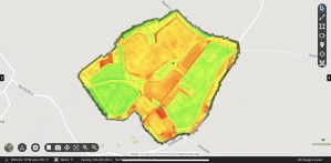
Large scale mapping

Step into the Future of Land Management
Unlock the potential of your land with our innovative drone-based mapping solutions, tailored specifically for the agricultural and construction sectors. Using cutting-edge technology, we provide accurate, reliable data that transforms the way you manage and understand your land.
Our state-of-the-art drones, equipped with advanced sensors and imaging technology, capture precise, detailed information about your land’s features. Whether you’re assessing crop health or mapping construction sites, our solutions offer comprehensive insights that empower you to make informed, strategic decisions.
With drone technology, we go beyond data collection – we revolutionize agricultural operations and construction management. Our solutions streamline processes, boost efficiency, and drive productivity, setting you up for success in every project.
Ready to revolutionize your land management? Contact us today to explore how our drone-based mapping services can elevate your operations and guide you towards a more sustainable and prosperous future.
Sustainable Farming Incentive (SFI) and Countryside Stewardship (CS)

Accurate Land Documentation for Agricultural Program Eligibility
For farmers aiming to qualify for programs like the Sustainable Farming Incentive (SFI) and Countryside Stewardship (CS), ensuring precise field boundaries and effectively documenting land use is essential.
At Straight Up Drones, we provide advanced solutions specifically designed to meet these critical agricultural needs. Our up-to-date imagery and mapping services equip farmers with the precise data required to meet program standards, optimizing eligibility for incentives and stewardship payments.
With our state-of-the-art drone technology and expert analysis, we deliver comprehensive insights that empower farmers to make informed land management decisions. Whether it’s delineating field boundaries, documenting crop rotations, or assessing land use practices, our meticulous approach ensures that farmers are fully equipped to meet the stringent requirements of these programs.
Ready to enhance your eligibility for incentives and stewardship payments while promoting sustainability in your farming operations? Contact us today to discover how our drone-based mapping services can support your agricultural success.
Crop Monitoring
Elevate Your Farming with Advanced Crop Monitoring
Step into a new era of agricultural excellence with our cutting-edge crop monitoring service, designed to transform proactive crop management.
Harnessing the power of advanced software and AI technology, we provide an unparalleled solution for swiftly detecting and addressing crop challenges, including pest infestations, disease outbreaks, and irrigation needs.
Our comprehensive service, featuring regular aerial flyovers and in-depth data analysis, empowers you to take control of your crop health with confidence. By identifying potential issues early, you can save valuable time and resources while boosting productivity and maximizing yields.
With a holistic view of your crops at scale, our monitoring service equips you to make informed decisions that drive success. Whether you’re a small-scale farmer or managing a large agricultural enterprise, we provide the tools and insights needed to optimize your operations and reach your goals.
Don’t wait for problems to arise—embrace our advanced crop monitoring service and experience the transformative impact it can have on your farm.
Prescription and Variable rate maps
Revolutionizing Agriculture with Variable Rate Application (VRA) Maps.
At the forefront of precision agriculture, Variable Rate Application (VRA) Maps are transforming how inputs like fertilizers, pesticides, and irrigation water are applied to crops, optimizing both efficiency and sustainability.
VRA Maps take into account crucial factors such as soil fertility, moisture levels, nutrient content, and crop health to deliver inputs precisely where they’re needed. This targeted approach ensures optimal plant growth and minimizes the risks of over-application or under-application, promoting healthier crops and improved resource management.
A key advantage of VRA Maps is their seamless integration with modern farming machinery equipped with precision agriculture technology. These maps can be easily uploaded to machine terminals, allowing for automated and precise application of inputs as equipment moves across the field. This automation enhances efficiency, reduces labor, and minimizes human error.
By adopting VRA Maps and precision agriculture techniques, farmers can reap significant benefits. Optimized input usage leads to improved yields, greater profitability, and a competitive edge in the market. Additionally, by reducing the need for excess fertilizers and pesticides, farmers can lower production costs and reduce their environmental impact. Precision agriculture fosters sustainable farming practices, promoting long-term environmental stewardship while ensuring economic viability.
Crop damage assessments
Addressing Crop Damage with Targeted Interventions.
Crop damage poses a significant threat to food security, nutrition, livelihoods, and economies, particularly in the face of climate change and extreme weather events. These challenges highlight the urgent need for accurate, real-time field and crop data to assess damage and implement effective solutions.
At Straight Up Drones, we provide precise field and crop data to support the development of targeted interventions tailored to the specific needs of affected areas. By analyzing this data, stakeholders can gain critical insights into the scope and severity of damage, enabling more informed planning and effective restoration efforts.
These targeted interventions are vital for safeguarding food security and livelihoods, as they help restore damaged land to productive use. Moreover, they contribute to building resilience against future climate-related challenges by strengthening the capacity of agricultural systems to withstand and recover from extreme weather events.
Index maps
Learn more about Multispectral Imagery and the different indexes here.
Harnessing Vegetation Indices for Plant Health and Ecosystem Monitoring.
Vegetation indices are essential tools for assessing plant health, conducting research, and monitoring ecosystems. They provide both visual and numerical insights into vegetation cover, distribution, and vitality, offering valuable information about plant growth patterns over time.
Among the various indices available, the Normalized Difference Vegetation Index (NDVI) and the Triangular Greenness Index (TGI) are particularly useful in crop nitrogen management and overall plant productivity.
NDVI is a widely-used metric for evaluating vegetation health and density. It utilizes sensor data from two specific spectral bands—red and near-infrared—to quantify plant health, making it an invaluable tool for monitoring large-scale agricultural operations and natural ecosystems.
TGI is closely correlated with chlorophyll content, making it a reliable indicator of plant health and nitrogen status. By leveraging TGI data, farmers and agronomists can optimize nitrogen management, ensuring that plants receive the necessary nutrients for optimal growth, yield, and quality. Given nitrogen’s essential role in plant metabolism, maintaining the right levels is critical to maximizing productivity.
To explore more about these and other vegetation indices, click here.
Spot spraying maps
We use AI and machine learning to help identify weeds and other areas of interest.
Spot Spraying Maps: Precision Solutions for Sustainable Agriculture.
Spot spraying maps, produced by Straight Up Drones, are high-resolution tools that pinpoint areas within a field where targeted agricultural inputs—such as pesticides or herbicides—are needed.
These maps provide several key advantages for farmers and agricultural practitioners:
Precision Application: Spot spraying maps allow farmers to apply inputs only where necessary, reducing waste and environmental impact by avoiding blanket applications across the entire field.
Cost Savings: By minimizing chemical usage and optimizing resource allocation, farmers can significantly reduce input costs, leading to improved profitability.
Environmental Benefits: Spot spraying maps support sustainable agriculture by reducing chemical runoff, lowering the risk of groundwater contamination, and protecting biodiversity by limiting the exposure of non-target organisms to harmful chemicals.
Enhanced Crop Health: By effectively managing weeds, pests, and diseases, these maps help farmers maintain crop health and productivity, resulting in higher yields and better-quality produce.
Overall, drone-generated spot spraying maps are a powerful tool for precision agriculture, enabling farmers to make informed decisions while applying inputs more efficiently, effectively, and sustainably.
Environmental Surveying

Environmental Surveying with Drone Technology.
At Straight Up Drones, we offer advanced environmental surveying services that harness the power of drone technology to capture detailed and accurate data about natural landscapes, ecosystems, and environmental conditions. Our state-of-the-art drone surveys provide critical insights that support environmental monitoring, conservation efforts, and sustainable land management.
Using high-resolution imagery and advanced mapping techniques, we create detailed 2D and 3D maps, allowing for precise measurements of topography, vegetation cover, water bodies, and wildlife habitats. Whether you’re conducting environmental impact assessments, tracking changes in ecosystems, or monitoring conservation areas, our drone surveys offer an efficient and effective way to gather essential data.
Key Benefits of Our Environmental Surveying Services:
Accurate and Up-to-Date Data: Drones provide a comprehensive view of environmental conditions, capturing real-time information that helps in assessing land use, habitat health, and ecosystem changes.
Non-Invasive Monitoring: Our surveys offer a non-invasive method for tracking wildlife populations and sensitive ecosystems without disturbing the natural environment.
Cost and Time Efficiency: Drone technology reduces the time, cost, and manpower traditionally required for environmental surveying, while delivering highly accurate and actionable data.
Detailed Analysis: From topographic surveys to vegetation indices and water quality assessments, our services deliver the precise information needed to support sustainable decision-making and land management.
Our drone-based environmental surveys are tailored to the unique challenges of your project, providing you with the data and insights necessary to make informed and responsible environmental decisions.
Contact us today to learn how our environmental surveying services can assist with your conservation, land management, or environmental research needs.
Trial plot management & Annotations
New Insights for Research and Commercial Plot Trials.
Trial plots are essential tools for both research and commercial purposes. In the agricultural sector, commercial trials are commonly used to showcase the performance and value of products, techniques, or strategies to potential customers, providing tangible evidence of their effectiveness.
Enhance the value and clarity of your trial data by adding annotations, including text and photos, directly to your maps. This feature enables you to convey detailed, actionable information that can be easily understood and shared with your team.
Additionally, our platform provides plot-level statistics and measurements that are accessible to everyone on your team. These can be viewed, edited, and updated in real time, ensuring that the latest data is always available for informed decision-making.
By leveraging these tools, you can ensure your research and commercial trials provide comprehensive, easy-to-understand insights that drive successful outcomes.
Digital surface models and Contour lines


Optimize Your Irrigation and Land Management with Elevation Modelling.
Are you looking for deeper insights into irrigation variability or need to identify flood and erosion-prone areas in your fields?
Our elevation modelling services provide the precise data you need to address these challenges. By generating detailed topographic maps, we help you better understand the landscape of your fields.
Contour lines, which connect points of equal elevation, are a key feature of our models. These lines reveal the shape and slope of the land, offering valuable insights into how water moves across your property. This information is essential for optimizing irrigation practices, mitigating erosion risks, and managing flood-prone areas.
Contact us today to discover how our elevation models can help you improve your irrigation efficiency and enhance your land management strategies.
Coastal erosion monitoring
Comprehensive Beach Erosion Monitoring with Straight Up Drones.
The stunning footage featured in the video above was captured by our team at Happisburgh, located on the scenic East coast of the United Kingdom. Using state-of-the-art drone technology, Straight Up Drones provides coastal managers with an invaluable tool for assessing beach erosion and its impact on coastal habitats.
Our drones can efficiently and safely cover large areas, delivering high-resolution imagery and detailed maps that offer an unparalleled perspective of the coastal landscape. These visuals allow coastal managers to thoroughly understand the extent and severity of beach erosion and its effects on surrounding ecosystems.
Through regular drone surveys, changes in beach erosion and habitat conditions can be closely monitored over time. This ongoing data collection enables coastal managers to identify long-term trends, guiding informed decisions on management strategies and the implementation of coastal defence measures.
At Straight Up Drones, we offer a complete solution for coastal managers seeking to monitor, understand, and mitigate the effects of beach erosion. Our advanced technology and expertise are here to support your efforts in preserving the natural beauty and resilience of coastal environments for future generations.
Excavation & groundworks

Enhance Your Earthwork Projects with Straight Up Drones.
Straight Up Drones offers cutting-edge drone solutions to assist with earthwork projects, providing precise measurements of dirt movement and efficient billing management. Here’s how our services can benefit your project:
Accurate Dirt Movement Measurement: Our drone surveys provide precise data on the volume of dirt that needs to be moved during excavation and grading. With detailed information on cut-and-fill volumes, contractors can plan and execute earthwork operations with greater precision.
Effective Billing Management: Our precise measurements enable contractors to invoice clients based on the actual volume of dirt moved, ensuring transparent and accurate billing. This approach reduces disputes and ensures fair compensation for the work completed.
Cut-and-Fill Calculations: We offer highly accurate cut-and-fill calculations, minimizing errors compared to traditional methods. This allows contractors to optimize resource use, reduce material waste, and keep projects on schedule and within budget.
Reliable Haul Cost Estimates: With precise volume measurements, contractors can estimate haul costs more accurately, improving planning for transportation logistics, equipment deployment, and material deliveries, resulting in better project efficiency and cost savings.
Real-Time Progress Tracking: Our drone surveys deliver real-time data on earthwork progress, allowing teams to monitor changes in terrain elevation and track excavation and grading activities. This data can be shared easily with team members and clients, enhancing collaboration and ensuring transparency throughout the project.
View, collaborate & share
Effortless Access to Your Maps, Models, and Documents with Our Customer Portal.
Streamline your project management with Straight Up Drones’ user-friendly customer portal, designed to provide effortless access to all your completed maps, models, and documents in one centralized location.
Our portal simplifies data management, offering a comprehensive repository for all your project-related assets. Whether you’re in the office or out in the field, you can seamlessly view and edit your maps from any device. The intuitive interface makes navigating through your project data easy, with real-time location visibility for quick reference and spatial context.
Additionally, our portal allows for secure and selective data sharing with your team, clients, and suppliers. Collaborate on projects, communicate progress updates, or share deliverables effortlessly, all while streamlining your workflows and improving communication.
Experience the convenience and versatility of our customer portal—empowering you with seamless, anytime access to your project data. With Straight Up Drones, managing your mapping projects has never been easier.
Forestry management

Revolutionize Forest Monitoring with Advanced Drone Mapping.
Traditional forest and woodland monitoring often requires labour-intensive and time-consuming foot patrols. At Straight Up Drones, we offer a transformative solution that saves time and resources while delivering highly accurate results.
Using multispectral drones, we provide fast and precise identification and quantification of trees. By analyzing tree crown reflections, our drones can quickly assess tree conditions, enabling the rapid identification of areas that need attention or intervention.
Our mapping services go beyond simple identification. We deliver detailed assessments of forest structure and individual tree properties through high-resolution mapping in the visible spectrum. This comprehensive approach provides stakeholders with critical insights into forest health, from overall canopy structure to the condition of individual trees.
By utilizing our advanced mapping services, forest managers, conservationists, and researchers can streamline their monitoring processes, gaining access to timely, actionable data that supports informed decision-making and targeted interventions.
With Straight Up Drones, you can enhance forest management practices, ensuring the long-term health and sustainability of forest ecosystems.
Reports & documentation

Customized PDF Reports Tailored to Your Industry Needs
At Straight Up Drones, our customized PDF reports cater to a wide range of industries and applications, ensuring that you have the vital information you need at your fingertips:
Agriculture Insurance: Our detailed reports provide valuable insights into crop health, field conditions, and risk assessments, helping agriculture insurance providers make informed decisions and streamline claims processing with confidence.
Agronomy: Precision and efficiency are critical in agronomy. Our mapping services are designed to meet the unique needs of agronomists, offering comprehensive data and actionable insights to optimize crop management and maximize yields.
Ecosystems Conservation: Conservationists benefit from our in-depth reports, which offer crucial information on habitat distribution, biodiversity hotspots, and land use patterns, supporting informed conservation planning and habitat restoration efforts.
Resource Management: Our reports provide actionable insights into natural resource utilization, land cover changes, and environmental impact assessments, promoting sustainable resource management practices across a variety of industries.
Turf Management: Our detailed analyses of turf health, vegetation density, and other key metrics enable turf managers to implement precise maintenance strategies, ensuring lush, healthy landscapes.
With our advanced mapping services and customized PDF reports, you can unlock the full potential of your data, empowering you to make informed decisions and drive success in your industry.
Partner with Straight Up Drones today and experience the power of actionable insights tailored to your specific needs.
As-built & Jobsite documentation

Real-Time As-Built Updates for Seamless Project Management.
Stay fully informed on the progress of your project with our regular as-built updates, available in both 2D and 3D formats. Our service enables you to remotely visualize, measure, and track changes at every stage, providing critical insights into the evolving landscape of your site.
By comparing as-built data with the original design plans, you can swiftly identify discrepancies, mitigating the risk of costly rework. Our detailed analysis helps pinpoint errors, inconsistencies, or deviations from the initial design, enabling timely adjustments and corrective actions.
Additionally, our platform offers a chronologically organized digital record of your project, making it easy to reference and document progress. This archive serves as a valuable resource for project management, quality assurance, and compliance, ensuring transparency and accountability throughout the project lifecycle.
With our as-built updates and advanced visualization tools, you can streamline project management, enhance decision-making, and minimize the risk of delays or setbacks.
Choose our service today and experience the advantages of real-time monitoring and comprehensive digital documentation for unparalleled project oversight and control.

Accurate 3D modelling
This is a fly through video that shows a local reservoir 3d model we made.
Our Pricing and what's included
Comprehensive Mapping Solutions Tailored to Your Specific Needs.
At Straight Up Drones, our mapping services go beyond simple imagery. We deliver a full suite of solutions that are not only competitively priced but also designed to meet the precise needs of your project, whether it’s in agriculture, construction, resource management, or any other industry. Our approach ensures that you’re not just receiving a map—you’re gaining a valuable tool that will transform how you plan, manage, and assess your operations.
What’s Included in Our Mapping Services:
Initial Consultation & Project Setup:
We begin by conducting a detailed, in-person consultation to fully understand your project goals and requirements. Whether you’re planning agricultural analysis, construction site monitoring, or environmental assessments, this consultation ensures that we tailor our approach to meet your specific needs. We’ll finalize details like location, project timing, and deliverables, ensuring nothing is overlooked. Additionally, we set up your customer portal during this meeting and provide a hands-on demonstration, so you and your team can seamlessly access and work with your maps from day one.
Pre-Flight Planning & Job Pack Creation:
Prior to deploying our drones, we carry out meticulous pre-flight planning. This includes a site survey to assess any potential hazards, check airspace restrictions, identify emergency contacts, and review environmental factors that might influence the flight. Safety and compliance are top priorities, and we handle all aspects, including the preparation of method statements, risk assessments, and the documentation required to secure flight authorization from relevant regulatory bodies. Our thorough planning ensures each flight is conducted with the utmost safety, efficiency, and compliance with local laws and regulations.
Survey Flights & High-Quality Data Collection:
Our licensed and insured drone pilots use cutting-edge UAV technology to conduct aerial surveys across a wide range of conditions, excluding rain. Whether your project requires hundreds or tens of thousands of images, our fleet of drones can efficiently collect the data you need, even for expansive areas. We leverage advanced drone sensors capable of capturing high-resolution imagery in a variety of formats (RGB, multispectral, etc.), ensuring that no detail is missed. Our ability to fly in challenging terrains and weather conditions, with strict adherence to safety and regulatory standards, allows for consistent, reliable data collection.
Image Processing & Custom Editing:
After the data collection, our team processes the raw imagery using industry-leading software to transform it into detailed maps and models. This process may involve custom image editing to meet your specific needs, such as adjusting colours to enhance visibility or applying filters to emphasize certain data points. Whether you need images optimized for field inspections or presentations, we ensure the final product is perfectly aligned with your project goals. Once processed, your maps are uploaded to your customer portal, ready for viewing, editing, and sharing with your team.
Comprehensive Access via Customer Portal:
Our intuitive customer portal gives you centralized, easy-to-use access to all your completed maps and data. Whether you’re in the office or out in the field, you can view, compare, measure, draw, edit, save, and share maps from any device. Our mobile app, designed to mirror the desktop version, allows you to view your maps in real time while on-site, even showing your current location for accurate, ground-level inspections. This flexibility makes it easy to incorporate our mapping services into your daily operations, allowing you to collaborate with your team, track project progress, and make data-driven decisions on the go.
Pricing Structure:
We believe in transparent and competitive pricing to ensure you get the best value for your investment.
Orthomosaic Mapping:
- First flight: Starting at £7.50 per hectare, this includes RGB images and a TGI (Triangulated Greenness Index) map.
- Additional flights: For the same area, these are priced at £5 per hectare, allowing for ongoing monitoring and project updates at a reduced rate.
Multispectral Mapping:
First flight: Starting at £12.50 per hectare, this includes all the features of orthomosaic mapping, plus your choice of 3 from 6 additional indices (such as NDVI, NDRE, or LCI), providing more in-depth analysis of crop health or land conditions.
Additional flights: For the same area, priced at £10 per hectare, ideal for seasonal monitoring or tracking changes over time.
(*Note: Prices are based on data collection for areas of 100 hectares or more per visit.)
Additional Services & Features:
Ground Sampling Distance (GSD):
Our standard mapping services provide high-resolution imagery with a Ground Sampling Distance (GSD) of approximately 3 cm/pixel, offering detailed visual representations of your fields or site. If your project requires a higher level of detail, we can adjust the GSD to meet your specific requirements. While a smaller GSD will result in more granular imagery, this will also affect the amount of data collected and the time required for processing, giving you flexibility based on your needs.3D Modelling:
For projects requiring an additional level of depth, we offer 3D modelling services, creating detailed, interactive models of your landscape or site. These models provide valuable insights into elevation, slope, and terrain, enabling better planning for construction, excavation, or land development. Prices start at approximately £75 per hectare, with final costs determined on a per-job basis, ensuring that the service is customized to your project’s scope and complexity.
Why Choose Straight Up Drones?
At Straight Up Drones, we believe that accurate, actionable data is key to making informed decisions that drive success. When you partner with us, you’re not just investing in a mapping service—you’re gaining a complete solution that integrates seamlessly into your operations. Our high-resolution maps deliver far more detail than Google Maps or other generic services, offering unparalleled clarity at ground level. Whether you’re managing large-scale agricultural operations, planning construction projects, or overseeing environmental conservation, our services are designed to support your goals with precision and reliability.
Contact us today to learn more about how Straight Up Drones can elevate your project with our comprehensive mapping services, tailored to your needs and delivered with expertise.

